A Tangled Legacy, Now Untangled
Imagine this: you’re standing on a stretch of land in rural Karnataka, unsure who owns it, what it’s meant for, or whether it’s even legal to build on. You’re not alone — thousands have faced this very puzzle.
Land ownership in Karnataka has long been entangled in bureaucracy, unclear boundaries, missing survey maps, and, too often, misinformation. Into this complexity steps Dishaank, a mobile application designed to demystify the invisible lines of land ownership and bring a layer of transparency that was once unimaginable.
Backed by the Department of Revenue and built by the Karnataka State Remote Sensing Applications Centre (KSRSAC) as part of the Bhoomi project, this app doesn’t just mark land on a map — it marks a new chapter in governance.
What Exactly Is Dishaank?
At its heart, Dishaank is a digital window into land records. With nothing more than a smartphone, users can access survey numbers, ownership information, land boundaries, and classifications, all mapped neatly using GIS (Geographic Information Systems) and satellite imagery.
What was once locked away in files and folders inside dusty government offices is now available — quite literally — at your fingertips.
Key Features – Unpacking the Magic
Accurate, Up-to-Date Land Details
Lookup RTC (Record of Rights, Tenancy and Crops) data for any survey number.
View ownership details, land usage (agriculture, residential, etc.), and whether it’s government or private land.
Smart, Location-Aware Design
Real-time GPS pinpointing lets you check the land beneath your feet.
Interactive maps allow for zooming in and out, selecting plots, and browsing areas with ease.
Bhoomi Database Sync
Unlike static maps, Dishaank is connected live to the Bhoomi land record system — making it current and reliable.
Multilingual Simplicity
Available in Kannada and English, ensuring ease of use for locals and officials alike.
Built-in Transparency Tools
Especially useful when buying land: check the legal land type, ownership, and possible restrictions before committing to a deal.
How It Empowers Citizens on the Ground
Prevents Land Fraud
Land scams, encroachments, and unauthorized sales — all thrive in secrecy. Dishaank brings visibility and transparency to help end them.
A Lifeline for Farmers
Knowing the exact boundaries and official classification of your land helps secure crop loans, subsidies, and claim eligibility in schemes.
A Trust Tool for Buyers
You don’t want to buy forest land thinking it’s residential. With Dishaank, you won’t.
A Planner’s Companion
From taluk offices to Panchayats, administrators now have a satellite-verified, easy-to-use map to make smarter decisions.
A Real-World Example – Ramesh’s Story
Ramesh, a mid-sized farmer from Tumkur, wanted to lease three acres of his farmland to a solar energy company. But paperwork delays were piling up. Instead of running pillar to post, he opened the Dishaank app, found his land on the map, showed live boundaries, and proved ownership — right in front of the officials.
What might have taken weeks? Solved in minutes.
Pros and Cons – What Works, What Doesn’t
Pros
- Fast, visual access to real-time land data
- Helps prevent forgery and land disputes
- Free and backed by the Karnataka Government
- GPS-based mapping, even in rural areas
- Kannada and English language support
Cons
- Not a legally binding document in court
- Accuracy might vary slightly in hilly or forested areas
- Not all taluks are fully digitized yet
- May struggle with low internet connectivity in villages
- Interface can be tricky for non-tech-savvy users
Is Dishaank Legally Valid?
Here’s the catch: No, Dishaank data isn’t legally binding.
While it provides accurate, helpful, and government-sourced information, legal proceedings still require official land documents from the Revenue Department.
Think of Dishaank as your real-time preview — not the final paperwork.
How to Get Dishaank App on Your Phone
For Android Users:
Open the Google Play Store, search for “Dishaank KSRSAC” and install the app.
For iPhone Users:
As of now (July 2025), the app is not available on iOS, but future updates are expected.
How to Use the Dishaank App – In 5 Simple Steps
- Install the app from the Play Store
- Enable location services for real-time tracking
- Search using village name, survey number, or your GPS position
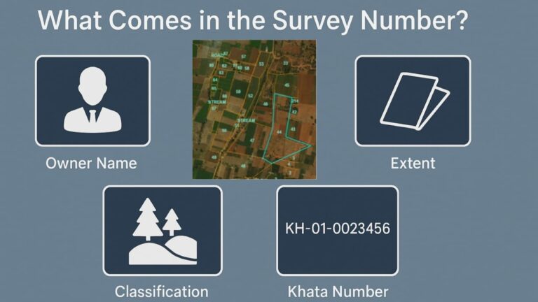
- Tap on the land plot to view:
- Owner Name
- Survey Number
- Land Size
- Land Classification
- Khata Number
It’s almost like holding a virtual land record in your palm.
Looking Ahead – The Future of Dishaank
The app is already revolutionary, but imagine this:
- Court case overlays to know if a plot is in dispute
- Mutation status integration to track ongoing land changes
- AI and Satellite Detection for encroachment alerts
- iOS Support to reach more users across India
If even half these features go live, Dishaank could become the Google Maps of land records.
Final Verdict – A Must-Have for Every Land Stakehold
The Dishaank app is more than a piece of tech — it’s a citizen empowerment tool. From villagers checking their ancestral land to urban buyers eyeing plots outside city limits, Dishaank serves as an honest, transparent, and efficient guide.
Does it replace legal documents? No.
Does it make your land journey ten times easier? Absolutely.
Rating: 4.5 out of 5
Dishaank isn’t just an app — it’s a silent revolution in your pocket.