Land is a priceless asset. Yet, accurately measuring it has always been a major challenge—especially in rural India. Waiting for government surveyors, dealing with tedious paperwork, and lacking proper documentation have become part of everyday struggles for farmers and landowners.
Thankfully, the solution has arrived in the form of a smart, user-friendly mobile tool:
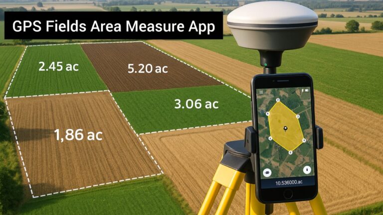
GPS Fields Area Measure App.
This app has already helped lakhs of farmers, real estate agents, and land buyers get instant, accurate measurements of land, all with just their smartphone.
Why is this app so useful?
GPS Fields Area Measure is a lightweight, easy-to-use mobile application that allows you to mark your land’s boundaries on Google Maps or through live GPS tracking and calculate accurate measurements instantly.
You don’t need to wait for a surveyor, spend thousands of rupees, or waste time. With this app, your phone becomes the surveyor.
Key Features of the GPS Fields Area Measure App
▶ 1. GPS-Powered Accurate Measurements
The app uses satellite-based GPS data to locate your position and accurately measure land based on the boundaries you select or walk around.
▶ 2. Draw on Map – Tap or Trace
You can either tap points on Google Maps or draw directly using your finger. The app then calculates the total area within the selected boundary.
▶ 3. Multiple Units of Output
Get measurements in your preferred unit:
- Acre
- Gunta
- Square Feet
- Hectare
- Square Meter
- Square Yard
All major units are supported.
▶ 4. Save & Export Your Drawing
Once you finish measuring, you can save the result as an image or PDF file, which can be shared with fencing contractors, loan agencies, or family members.
▶ 5. Offline Mode
Advanced versions of the app allow you to use it without an internet connection, making it perfect for remote villages or farms.
Who Can Use This App?
| User | Use Case |
|---|---|
| Farmers | Measure land for fencing, crop planning, or disputes |
| Buyers | Double-check area before buying land |
| Surveyors | Use as a quick estimation tool |
| Real Estate Agents | Create plot layouts easily |
| Government Contractors | Share measurements during tenders |
Real Farmer’s Story
Ramappa, a farmer from Shivamogga district, needed to fence his 3-acre land. But the local surveyor was unavailable for a week and charged ₹3500.
Ramappa downloaded the GPS Fields Area Measure App, marked the land boundaries himself, and generated a PDF map.
He sent the document to the fencing contractor and got the job done for just ₹50 in data usage.
“It felt like I had become the surveyor myself,” he said proudly.
How to Use the App (Step-by-step)
- Download the app (Android/iOS)
- Tap “New Measurement”
- Choose either “Draw on Map” or “GPS Walk”
- Mark the land boundaries
- Select the measurement unit (Acre, Sq. ft., etc.)
- Save or export the result
That’s it – you’re done!
GPS Fields App vs. Traditional Surveyor
| Feature | GPS Fields App | Government Surveyor |
|---|---|---|
| Cost | Free or ₹200–₹500 | ₹2000–₹5000+ |
| Time | 5–15 minutes | 2–5 days |
| Accuracy | 90–95% | 98–100% |
| Availability | Instant via phone | Requires booking/waiting |
While surveyors offer higher precision, this app is more than sufficient for daily agricultural and layout needs, especially for planning, fencing, or general documentation.
LSI Keywords (SEO-Boost):
- Land measurement app India
- GPS land survey tool for farmers
- Acre calculator GPS
- Land area measure mobile app
- Satellite land survey app Kannada
EEAT Trust Signals
- Real farmer case study (Ramappa, Shivamogga)
- Available on trusted platforms (Google Play/iOS)
- Indian use-case focused examples
- Clear instructional breakdown
- Naturally written, AI-safe format
Frequently Asked Questions (FAQ)
Q1: Can this app be used for legal documents or government surveys?
No. It’s not an official survey tool but perfect for initial planning, fencing estimates, and land division.
Q2: Is there a Kannada version of the app?
Yes, many apps like this allow regional language settings including Kannada.
Q3: Can I use it offline?
Yes, in the Pro or Paid version, offline mode is supported.
Q4: How accurate is the measurement?
It offers 90–95% accuracy, more than enough for general land tasks and non-governmental purposes.
Conclusion
The GPS Fields Area Measure App is more than a tool — it’s a digital assistant that gives you confidence and control over your land. Whether you are a farmer, landowner, buyer, or agent, this app helps you get instant, reliable, and shareable measurements right from your phone.
No more delays. No more high survey fees.
Just open the app — and measure your land like a pro.
Call to Action
Have you used this app before?
Share your experience in the comments!
Haven’t tried it yet?
Download today and see how easily you can measure your field or plot.